A century in Beijing: Difference between revisions
No edit summary |
No edit summary |
||
| Line 179: | Line 179: | ||
There are only some little problems in the way of translate the name into English. He tends to transliterate certain buildings and then add a detailed explanation of the transliteration in the description. And there is no problem in the remaining part, including the Chinese name and references. | There are only some little problems in the way of translate the name into English. He tends to transliterate certain buildings and then add a detailed explanation of the transliteration in the description. And there is no problem in the remaining part, including the Chinese name and references. | ||
== motivation and description of the website == | |||
In the nearly one hundred years of development, the face of Beijing has changed a lot. There are many temples and buildings that have been demolished. Although no specific photos can be found on the old maps, these old maps at least prove the existence of these buildings. And we hope that the changes in Beijing will be presented by putting together the maps of old and new Beijing. In this way, not only can the changes in Beijing be presented, but also the current situation in Beijing can be better understood. For example, many places in Beijing now originate from the old buildings in Beijing. When these buildings were demolished, people only know the current place names, but they don't know how the place name came from and the story behind it. | |||
== Detailed description of the methods == | == Detailed description of the methods == | ||
Revision as of 00:16, 17 December 2018
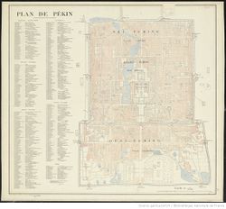
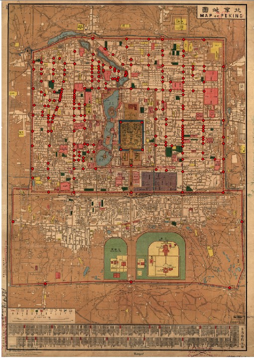
Using this map by France's Service Géographique de l'Armée from 1900 we will follow the evolution of the urban landscape of the central part of China's capital at several milestones through the decline of Qing dynasty, the birth of a republic, the establishment communism to the modern times. The city grew vey quickly over the last hundred years and is now way past its old borders. While some things in the downtown remained pretty unchanged like the Tiananmen Imperial Palace, numerous old constructions were demolished in an effort to modernize the town.
Outline
Sources
Goals
- To align maps from different time periods and see how the landscape changed. The town's straightforward rectangular planning will allow us to make matches more easily.
- Incorporating the geodata for finding places.
- The map has a rich legend with toponymic information in French and the dated French system of transliteration of Mandarin. The plan is to extract and match these place names with their modern counterparts.
- Add the old pictures of significant buildings that are no longer there if it's possible to find them.
- To present the results as a web resource.
Tools
- Google Firebase – non-SQL web-based database
- QGIS – map alignment software
- Google Cloud OCR – text recognition tool
- HTML, JS etc. – basic standard web development instruments
Project plan
- Find a proper map that can be used to align and containing enough information.
- Align the old map with the mordern one.
- Compar these two maps and extract the area where building changed.
- Extract the coordinates of the old building.
- Creat a database to record the name, function of the old building and the name and function of the current one.
- Compar these two maps and extract the area where the function of building was changed.
- Extract the coordinates
- Creat a database to record the name, function of the old building and the address of the appartment currently.
- Crea a website which can display the difference of two maps in an interactive way.
- high light all the areas which were rebuilt or function have been changed in different colors.
- For the area which were rebuilt:When putting cursor on this area,pop up window to show the instruction of old buildings and the current one.
- For the buildings which function were changed:When putting cursor on this area,pop up window to show the function of these departments and hight light the area where the current dapartment is.
Milestones
| Timeframe | Task | Completion |
|---|---|---|
| Week 8 | ||
| 07-09.11 | Choosing tools for the map alignment | ✓ |
| Aligning the old map with the modern satellite map | ||
| Applying DH-segment to automatically extract street and buildings’ shapes | ||
| Using Google OCR to extract word description | ||
| Evaluating current results | ||
| Selection of more suitable old maps | ||
| Week 9 | ||
| 14-16.11 | Map alignment | ✓ |
| Preparation of the midterm presentation | ||
| Week 10 | ||
| 21-23.11 | Developing the database structure | |
| Extracting the building shapes from the old map | ||
| Planning for the development of a website with the map | ||
| Week 11 | ||
| 28-30.11 | Finishing all the extraction jobs | |
| Adding the data to the database | ||
| First version of the website | ||
| Week 12 | ||
| 05-07.11 | Adding interactive functions | |
| Finishing the website | ||
| Week 13 | ||
| 12-14.12 | Project report | |
Historical introduction to the map
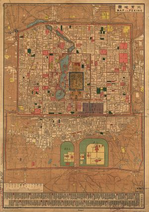
This is a Map of Beijing. Printed by Chung Tung Litho Work (Zhong Dong Shi Yin Ju), Tianjin, in 1914. Scale 1:15,850.
In this year, the Republic of China has just been established for three years. The capital of China has returned to Beijing from Nanjing. Since the Republic of China was just established at this time, there have been no major changes and changes in the buildings in Beijing. However, many of the original buildings of the Qing Dynasty were requisitioned by the government as the new functional departments of the Republic of China. For example, the Congress of the Beiyang Government, the various government departments have appeared on the map, and the Presidential Palace has been stationed in the Forbidden City.
The whole picture focuses on the distribution of buildings and streets in the city. The government departments are shown in red on the map, the school on green, the temple on yellow, the water in light blue, and the embassies and diplomatic sites in purple. By distinguishing these important places from other places through the use of different colors, these geographical matters are more conspicuous. Other building streets are more abbreviated, and there is no function or name. Some of the place names in the map are in Chinese and English, but the proportion of place names with English translation is not high. And below the map, there is a list of offices in the capitals of the provinces.
At the end of the Qing Dynasty and the beginning of the Republic of China, the trend of Western learning was becoming more and more popular, and the mapping of maps was mostly based on Western methods. This map is a good example. Compared with the traditional Chinese map, which is accustomed to flatten the shape of the building, miniaturization (more emphasis on the style of the building and the approximate relative positional relationship, while the scale is not very important). This map uses uniform geometry, symbols and colors to represent similar things. At the same time, the figure uses a scale of 1:15 850 to further increase its accuracy.
Detailed Method
The methods are mainly 2 parts, one is the information exacting part, another is the website building part. Information exacting:
All the useful information in the map is presented in Chinese, following steps need to be finished in order to exact the information:
1. Aligning the map
Although this version old map of Beijing is much more accurate than other maps in the same generation, there are still a lot of distortion compared to the modern map. In order to exact the information more effectively, we need to align it at first. The tool used to align the map is the Georeferencer in QGIS. The idea is to load an image of a map into QGIS, mark at least three points on the raster image (our historic map) and where they correspond to the vector image (current map).
Since we want to present the map in website aligned on the modern map layer, we need to make the alignment as detailed as well. So I used a lot of mark point to do the alignment.the feature points selected for the alignment is depends on observation the satellite map, finding out the place that haven’t changed yet, and mark them on both old and current map.
2. exact information Since there is only the name of important buildings in the old map, in this situation, information is not enough for us to find the differences between old Beijing and modern one, so we have to do the information expansion. After finding enough information, we will record all the information into a ,shp document, including :name, simple description, Chinese name, current use of the area, reference (where do I find the information )
1. read the name of the building in the map and then search them on the internet to fin out other possible names of the same place, the reason why we need to do that is the recorded name is that the name changes over time, may become a similarly pronounced name or be recorded in another way.
2. Since the database about the China 100 years ago is really not sufficient, there are a lot of information I can only find in personal blogs or books. So, the only thing I can do is to search the name on internet and try to find out some descriptions of the buildings.
3. After finding out the descriptions, I need to read the description, determine whether the information found is related to the place name recorded in the map or not.
4. According to the description that was found to translate the name into English, the simple description as well.
5. According to the location, find the modern usage of this area by reading the modern map, so that we can learn the usage of the same area in nowadays.
6. Document them in to .shp, including :name, simple description, Chinese name, current use of the area, reference (where do I find the information )
Quality assessment
As we can see that, the quality of information I extracted is not only about document the information into computer correctly, but also important that the information I found on the internet is right as well.
One thing is hard to check is the correctness of the information I found on internet, if there are more than one information source we can do some cross-validation to find out is the information trustworthy. But the problem here is that for a lot of the buildings, there is only few information source I can find, and these sources of information are referenced to each other.
So I decided to only check is the reference relative to the buildings we work with, but not test the authenticity of reference itself.
The part need to be checked including:
1. The original Chinese name.
2. The translation of name.
3. The description of old buildings.
4. The relevance of objects and their references,
5. The usage of the area currently.
The assessment I can do is to give another person the shp document that I used to record the name, the references and so on. And then ask him to view the content in reference and check is that relative, and then, ask him to check the translation of the name and the description.
I gave my friend around 30 items to check, and here is the result:
There are only some little problems in the way of translate the name into English. He tends to transliterate certain buildings and then add a detailed explanation of the transliteration in the description. And there is no problem in the remaining part, including the Chinese name and references.
motivation and description of the website
In the nearly one hundred years of development, the face of Beijing has changed a lot. There are many temples and buildings that have been demolished. Although no specific photos can be found on the old maps, these old maps at least prove the existence of these buildings. And we hope that the changes in Beijing will be presented by putting together the maps of old and new Beijing. In this way, not only can the changes in Beijing be presented, but also the current situation in Beijing can be better understood. For example, many places in Beijing now originate from the old buildings in Beijing. When these buildings were demolished, people only know the current place names, but they don't know how the place name came from and the story behind it.
Detailed description of the methods
- Outcome
- Code
