Alignment of XIXth century cadasters: Difference between revisions
Marin.piguet (talk | contribs) |
Marin.piguet (talk | contribs) |
||
| Line 20: | Line 20: | ||
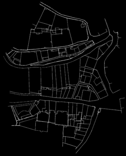
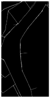
The method that gave the most satisfying results (in terms of final output and computation time) was the template matching. The strategy is to cut a template in one of the maps and find the best match in the other one. Attaching the two maps together is then an almost straightforeward task, as long as the lines prediction files are only black (0) or white (255) pixels, and the final result is just the sum of the two of them adapted with the best matching position. | The method that gave the most satisfying results (in terms of final output and computation time) was the template matching. The strategy is to cut a template in one of the maps and find the best match in the other one. Attaching the two maps together is then an almost straightforeward task, as long as the lines prediction files are only black (0) or white (255) pixels, and the final result is just the sum of the two of them adapted with the best matching position. | ||
[[File:DecoupeBerney_001.png|250px|thumb|First map of the Berney's cadaster]] [[File:DecoupeBerney_002_decoupe.png|100px|thumb|Template selected manually on the second map]] | |||
==== Automatisation process ==== | ==== Automatisation process ==== | ||
Revision as of 15:43, 14 November 2021
Introduction
Organisation
Project first steps
Methods exploration on Berney's cadaster
For the primary research of methods to reattach cadastral maps, the so called cadastre Berney from Lausanne has been used, as long as the ground truth for this particular case is known and lot of processing steps (as lines and classes predictions) have already been made. The first exercise has been made on the two first maps, using the lines prediction files. The quandary was to be able to detect the common parts of these two maps, in this case the Rue Pépinet and the top of Rue du petit chêne. Many different methods have been tested for that task, mainly with help of the openCV python library.
(TODO : lister brièvement toutes les méthodes)
First reattachment of two cadastral maps
The method that gave the most satisfying results (in terms of final output and computation time) was the template matching. The strategy is to cut a template in one of the maps and find the best match in the other one. Attaching the two maps together is then an almost straightforeward task, as long as the lines prediction files are only black (0) or white (255) pixels, and the final result is just the sum of the two of them adapted with the best matching position.
Automatisation process
After this liminary result, a lot of question were nevertheless still to be answered. For example, is the orientation of our maps precisely in the North direction ? Will it be possible to have an explicit order of maps reattachment ? Will the matching score be as good in the countryside as it was in the city ? Is the scale homogenous within an entire city ? Or what criteria could be used to automatise the template selection ?
Final milestones of semester
| Column1 | Column2 | |
|---|---|---|
| Week 11 | Find a method to align one cadastral maps on the OSM extraction. | Try first on Berney's cadaster ? (obviously using TIFF just for verification) |
| Week 12 | Try to apply this method to all the maps that we have been able of reattaching together so far. | |
| Week 13 | Improve methods and automatisation of different steps | |
| Week 14 | Final presentation |

