Traghetti in Venice
Introduction and Motivation
The city of Venice is widely known for its network of canals and its iconic ferries, know as traghetti. While nowadays they mainly serve as a tourist attraction, the traghetti have played a vital role in the daily life of Venetians since the early days of the city, by enabling the movement of both goods and people [1]. By looking at ownership data from a Venetian census of 1740, this study will seek to explore who owned and how the Venetian traghetti were operated during this period.
This research will focus on three main aspects. First, we will investigate the ownership of the traghetti and try to identify the prominent entities that controlled them. We will then try to understand the motivations behind this ownership, by looking at other business ventures of the entity, its ownership layout in the city or other historical motives not necessarily found in the data.
Secondly, we will conduct a spatial analysis in order to explore the distribution of traghetti across Venice. Using the geographical data, we will try to understand the placement of the ferries throughout the city and what kind economic or societal factors determined their position. Finally, by using another historical record (the Venetian cadastre of 1808), we will try to analyse how the ownership and placement of the traghetti evolved trough the 68 years separating the two datasets.
Deliverables
- Python scripts production plots and maps for the entity analysis (entity_analysis folder)
- Jupyter Notebooks for matching Catastici and Sommarioni dataset and the results (catastici-to-sommarioni folder)
- Put basically what you have here !!!!!!!!!!!!!!!!!!!!
Project Timeline & Milestones
| Week | Task | Status |
|---|---|---|
| 14.10 - 20.10 | - Define research question | ✓ |
| Autumn Vacation | -------------------------- | ✓ |
| 28.10 - 03.11 | - Find and read litterature | ✓ |
| 04.11 - 10.11 | - Read litterature
- Extract owner data and provide early visualisations |
✓ |
| 11.11 - 17.11 | - Midterm presentations
- Visualisation tool for historical maps |
✓ |
| 18.11 - 24.11 | - Catastici and Sommarioni alignment
- Entity owned distribution - Traghetti Rental Prices Analysis |
✓ |
| 25.11 - 01.12 | - Catastici and Sommarioni analysis (ownership change, ...)
- Specific families/entities analysis - Spatial analysis of traghetti - Start writing the wiki |
✓ |
| 02.12 - 08.12 | - Analysis of intersections between squero and traghetti owners
- Analyse tenents (number of families?) - Compare results to present day data (if available) - Continue writing wiki |
✓ |
| 09.12 - 15.12 | - Finish writing the wiki | ✓ |
| 16.12 - 22.12 | - Spare week | ✓ |
Methodology
Data Extraction
For Catastici dataset, text_data and geojson are exactly the same, except for the geometry column. The difference in geometry column is likely that they adopted difference coordinate systems, and we prefer to use the geojson one for coordinates. Here are the fields we used in the Catastici dataset
- function: function of the parcel
- owner_family_name: owner last name (blank if owner is not an person)
- owner_code: code of owner type
- owner_entity_group: owner entity group standardisation (blank if owner is not an entity)
- owner_family_group: owner family group standardisation (blank if owner is not an person)
In order to work on traghetti, we need a way to extract each one from the data set. For this purpose we searched the keywords "traghetto/i" and "gondola/e" in the "function" column of the dataset using regex. Whilst exploring the data during the Entity Analysis, we discovered that the keyword "Libertà" also refers to the traghetti and included it in our regex. This choice will be motivated in the Discussion section.
For Sommarioni dataset, text_data and geojson have different lengths and columns. We prefer geojson file because it has the footprint around the parcel. We will use "parcel_number" to merge sommarioni into catastici and use "parcel_type" field for the type of the parcel, like "building", "courtyard", "sottoportico", "street", "water".
Entity Analysis
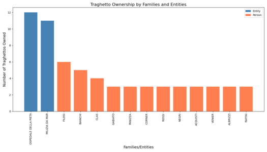
To understand who owns the traghetti, we wanted to delve into several such entities. For this process, we started by extracting all traghetto owners from the data set and made and histogram of traghetto ownership by Entity and Family. This gives us an idea of the most important families and entities in the traghetto business. Based on the results, we chose several specific entities that were interesting, for which we did a more in-depth analysis. For these entities, aside from searching them in historical articles, we plotted a histogram of everything that they owned with the following categories: shops, houses, traghetti and other. This already gives us an idea of the kind of entity we are studying, by discussing the number of properties owned, or the percentage of traghetti owned by these entities. We finally plotted these properties in the Venice map, to try and find any patterns for the placement of the traghetti.
Our work for the tenants followed relatively the same pattern. We found which families rent traghetti the most, then tried to find if there is a correlation between who rents and who they rent it from. Finally, we also plotted the proprieties they rented on the Venice map.
Catastici and Sommarioni merging
Here we are going to see what the traghetto in Catastici dataset (1740) change into in Sommarioni dataset (1808). There are fields indicating the usage of the parcel in both Catastici dataset and Sommarioni dataset, `function` and `parcel_type`, respectively. From the data, we can check how the functions of the parcel change. For example, a traghetti in 1740 in a parcel may still stay as a traghetti, or change into a garden. By merging and aligning the Catastici and Sommarioni dataset, we can see this evolution process.
There are two possible approaches for our dataset merging, id matching and coordinates matching.
1. id matching
We can align the entries in the Catastici dataset with those in the Sommarioni dataset by matching the `id_napo` field from the Catastici dataset to the `parcel_number` field in the Sommarioni dataset. We were trying to see if we can figure out if the ferries in Catastici dataset became something else in Sommarioni dataset, or which entries in Catastici dataset became ferries in Sommarioni dataset. The id matching could result in exact matching between entries in Catastici dataset and Sommarioni dataset.
2. coordinates matching
Another way to matching Catastici and Sommarioni dataset, is to match by coordinates. In Catastici dataset, we have the coordinates of the traghetto, which are individual point coordinates, like Point (12.34334 45.43827). In Sommarioni dataset, we have the footprint around the parcel, demonstrated as a polygon, like POLYGON ((12.3344614 45.4340889, 12.3344839 45.4340411, 12.3344957 45.434044, 12.3344726 45.4340918, 12.3344614 45.4340889)).
From the data, we can check if a traghetti in Castici dataset lies in the footprint of a parcel in Sommarioni dataset, by checking if the point is within the polygon. Thanks to geopandas, it's easy to conduct the check.
Origin-Destination Human Mobility Network
To explore the transport routes and potential usage of traghetti in Venice during 1740, we applied agent-based modeling to simulate transportation patterns within the city.
Data Classification First, we analyzed the catastici 1740 dataset by classifying the function column into the following categories:
- Residential
- Commercial/Retail
- Traghetto/Squero
- Religious/Institutional
This classification allowed us to understand the spatial distribution of land use in 18th-century Venice.
Agent Definition We assumed that individuals (or agents) often rented or owned spaces for both residential and commercial purposes. To identify agents, we:
- Extracted names from both the owner and tenant columns in the dataset.
- When the tenant column was null, we used the owner column as a fallback.
- Defined agents as individuals who rented or owned two or more properties.
Home-Workplace Extraction For each identified agent, we extracted one home and one workplace, In cases where individuals rented or owned multiple properties, we randomly selected one property as their home and another as their workplace.
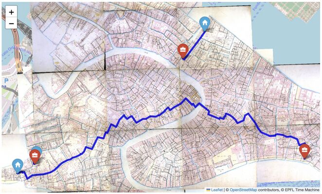
Route Simulation By linking the home-work locations for each agent, we simulated their likely transportation routes, emphasizing the role of traghetti as a vital part of the Venetian transport network.
Network Geometry Engineering
To further simulate how agents move between home and work locations, we used the Sommarioni 1808 road network provided by the Venice Time Machine. While this network is from a different period than the Catastici 1740 dataset, the absence of 1740 network data necessitated its use. Upon comparison with the Lodovico Ughi map (1729), the road networks were found to be largely consistent.
However, the initial road network data contained several issues, including:
- Many disconnected edges.
- Numerous unconnected components.
To address these issues, we applied a series of geometry engineering techniques:
- Used buffering and snapping tools in QGIS GRASS extension.
- Manually edited network geometries to fix inconsistencies.
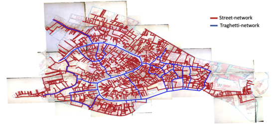
For the traghetti routes, we digitized the main pathways based on historical maps. We assumed that all traghetti routes were interconnected, enabling traversal between any two points serviced by them.
In the final stage, we ensured that the road network graph was fully connected, allowing movement between any two points on the network.
Transport Routes Modeling in Venice, 1740
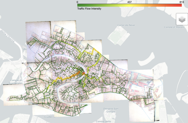
After preparing the data, we simulated agents' movements between home and work locations using a shortest path algorithm to determine their daily commute routes. The calculated routes were then aggregated to analyze traffic flow within the road network.
To assess the functional role of the traghetti, we compared traffic flow under two scenarios:
- Using the road network only.
- Allowing agents to travel via both the road network and the traghetti network.
By analyzing the flow differences between these two scenarios, we were able to better understand the impact and importance of the traghetti in Venice's transportation system during the 18th century.
Discussion
Data Extraction
While at first we did not think to include the key word libertà in our traghetto research, we found that they also refers to traghetti. Firstly, all traghetto entries in our dataset are in the form of libertà di traghetto, while all libertà entries appear jointly with traghetto or alone. Moreover, when we plot libertà entries on the map, their location appear in the same places, or as we would expect traghettos to appear.
In addition, we found that ownership stayed relatively similar with or without the addition of the libertà keyword. We still find Filosi or Corner at the top of the families list and Milizia da Mar or Ospedale della Pietà at the top of the entities list.
Finally, we found in a Venitian dictionnary written in 1856 that the word libertà is directly related to the traghetto business and means the “licence” to exploit a Traghetto in Venice [2]. Thus, based on this evidence, we can affirm that the keyword libertà is referring to traghetti and we will include them in our analysis. We hypothesize that the difference between libertà and libertà di traghetto in our dataset is based on the understanding of the Venician adminitistration, where it would be understood that libertà would exclusively refer to the traghetti, making the last word redundant.
Entity analysis
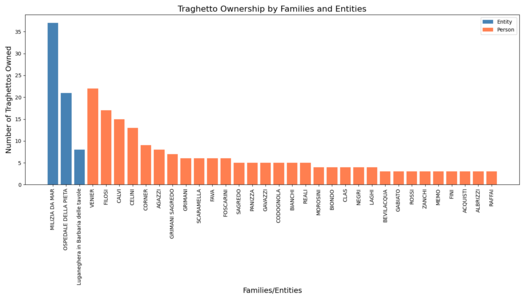
As discussed in the Methodology section, we started by plotting the traghetto ownership (for visibility, we excluded any entity or family that owns two or less traghetti):
In the entity column, two stand out: Milizia da Mar and Ospedale della Pietà. We will choose to focus on these two. Concerning the families, several stand out, but we will choose to focus on the families Venier and Celini.
Milizia da Mar
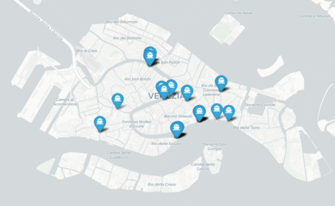
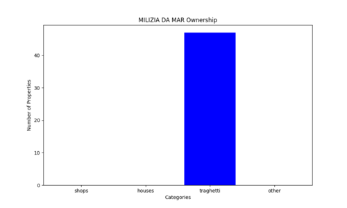
The Milizia da Mar is the name of the navy of Venice. Knowing this fact, and the importance of traghetti in the mobility of the city, it is natural that this organ would own this crucial utility. This is shown in the following histogram:
Ospedale della Pietà
The Ospedale della Pietà is one of the four Ospedali Grandi, charitable institutions forming the base of the Venitian welfare system. The Ospedale della Pietà was focused on housing abandoned children. These entities were also known throughout Europe as musical institutions, each child they housed receiving basic musical training, and the best performing in the Ospedali's renowned cori [3]. It is thus surprising to find this institution this high in the traghetto business, especially when the other Ospedali do not own any traghetti.
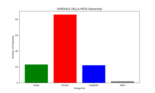
If we look at the Ospedale’s properties, we find that they specialise in housing. Knowing the purpose of the institution this is not surprising, as either to make money to subsidise their charitable work or to pay the famous music teachers, a good number of homes would be needed. What is interesting is that traghetti make up 15% of all properties owned by the institution and almost 50% of non-housing. The traghetti are thus a good portion of the investment from the Ospedale.
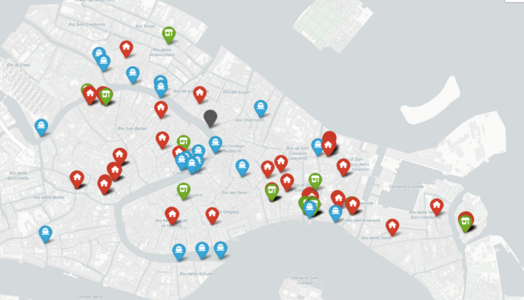
Finally, we tried to understand why Ospedale would own traghetti. We made the hypothesis that the placement of the traghetti would be either around their main building, to both give employment to the orphans they would welcome and to allow people to come to their building, or near their shops and houses to facilitate movement between their properties.
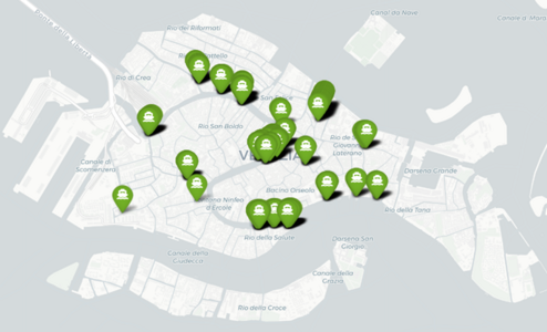
Instead, we this distribution. We see a high density of ownership around the Ospedale building, while many traghetti and general properties are scattered across the city. Unfortunately, it is hard to provide a satisfactory explanation of this data. Most of the proprieties could come from inheritance, where a childless family would give their properties to a charitable institution, but that does not explain the amount of traghetti owned by the Ospedale. Moreover, no article or book that we have found touches on this specific subject, leaving the only clues to be found probably in the archives of the Ospedale itself.
Venier
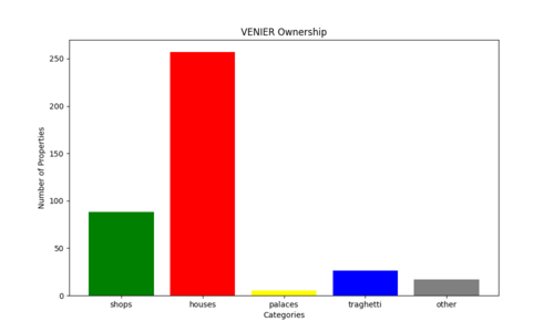
The Venier noble family is one of the most important families in Venice, notably having several Doges throughout Venice's existence [4]. As such, seeing that they are the family owning the most traghettos, it would be interesting to analyse them further. Like the previous instances, we started by looking at the family’s ownership situation. In this case, we included palaces as a separate category to show the social status of the Veniers.
Like the case of the Ospedale, the Venier family owns mostly houses and apartments. Being one of the richest families in Venice this result is not surprising. What is notable is the number of traghetti owned by the family compared to the other noble families, like the Pisani or Grimaldi families (families that had Venitian doges around 1740) [5]. This discrepancy might be understood by looking at the locations of the Venier’s traghetti.
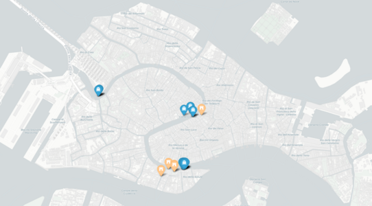
This map displays the position of the traghetti and palaces belonging to the Venier family. Unlike the Ospedale map, we can observe that the traghetti are in specific clusters, and mostly near the family’s palaces in the Rialto and in the south of the city. One can then hypothesize that the traghetti owned by the Venier family would serve to connect their palaces in the south to the important centres of the city.
Celini
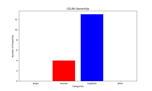
Unlike the Veniers, the Celini family is not a noble family and not much is known about them. Thus, their position as the fourth family owning the most traghetti is remarkable. We can look at their ownership status to try and learn more about the family.
Indeed, the Celini family only owns traghetti and a few houses. It would seem to be a family with a history of working and managing traghetti.
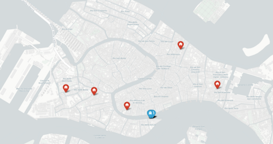
By looking at their ownership make, we can see that all their traghetti are at one end of the grand canal, right in front of the Basilica Santa Maria della Salute. We can then hypothesize that there would be a lot of movement at that crossing, which a family passing the traghetto business through generations would have access.
Catastici and Sommarioni merging
As is shown in Methodology part, we are going to use id matching and coordinates matching to see what the traghetto in Catastici dataset(1740) change into in Sommarioni dataset(1808).
1. id matching
We conducted id matching first because it's more exact than coordinates matching, However, the entries related to "traghetti" and "liberta" in Catastici dataset all have null `id_napo` fields. In this way, we cannot match those entries related to "traghetti" and "liberta" in Catastici dataset with the ones in Sommarioni dataset. In other words, id matching is not applicable on the current datasets.
2. coordinates matching
We found it not feasible to continue the matching with the exact ids, i.e. `id_napo` and `parcel_number`. Then we turn to check the coordinates of the ferries in the Catastici dataset, and see where these coordinates fall in Sommarioni dataset. We can tell if a coordinates falls into a parcel in Sommarioni dataset by checking if the coordinate falls within the footprint (a polygon) in Sommarioni dataset.
After checking the functions for these matched traghetto, we find 37 traghetto fall into 37 parcels in Sommarioni dataset, respectively. Among these 37 parcels, 30 are courtyards and 7 are buildings.
Looking into the owner family names, we find that the VENIER, CODOGNOLA, FOSCARINI, SAGREDO and ROSSI, all noble families in Venice, own 17 out of these 30 traghetto.
| Name | Count |
|---|---|
| VENIER | 5 |
| CODOGNOLA | 5 |
| (missing value) | 4 |
| GRIMANI SAGREDO | 3 |
| FOSCARINI | 3 |
| PANIZZA | 3 |
| SAGREDO | 2 |
| FILOSI | 2 |
| ROSSI | 2 |
| ALBRICI | 2 |
| RAFFAI | 2 |
| FAVA | 1 |
| CORNER | 1 |
| BERNARDI | 1 |
| TESSER | 1 |
Unfortunately, in the Sommarioni geojson dataset, there are no fields indicating the name of the owner, so we cannot compare the ownership here with the Catastici dataset.
To sum up, for the matching of Catastici and Sommarioni dataset, we find that the id matching doesn't work in our situation, and in coordinates matching, we didn't find any matched parcel in Sommarioni that is a traghetti. One possible reason could be Sommarioni is a cadastre (land registration) it would not show boats in the river but only parcels of land, showing that the way taxation worked changed during the 68 years separating the datasets.
Origin-Destination Human Mobility Network
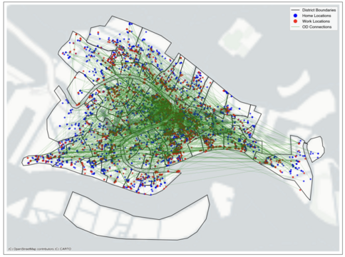
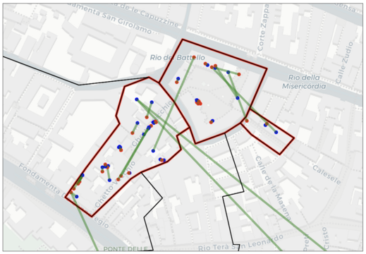
To visualize the spatial distribution of human mobility in 1740 Venice, we constructed the Origin-Destination (OD) network based on agents’ home and workplace locations. The O-D pairs analysis reveals significant spatial patterns in the home-work connections of agents in 1740 Venice.
By the links between agents’ homes and workplaces, we can observe that the central districts emerged as key hubs of activity, exhibiting a high density of destination points. This reflects the concentration commercial properties within the core areas, aligning with the urban fabric of Venice at the time.
Furthermore, in the Ghetto area, we observe a significant number of intra-regional OD pairs, indicating localized movement within this district. This aligns with the historical context, as the Jewish population was confined to the Ghetto during specific hours of the day.
Network Geometry Engineering
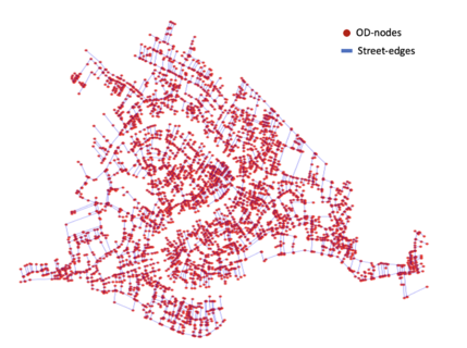
After completing a series of geometry engineering procedures using GIS software, we obtained a fully connected street network of Venice. This process ensured that all segments are topologically correct and fully integrated, enabling seamless movement across the network.
The Origin-Destination (OD) points were then projected onto the refined street network, making them ready for subsequent analysis of human mobility patterns.
The traghetti routes—the key gondola crossings in Venice—were incorporated into the network. Notably, access to these traghetti routes is only allowed at designated traghetto locations identified in the catastici of 1740. The completion of both road and canal network data provides a foundation for modeling mobility and transportation patterns in historical Venice.
Transport Routes Modeling in Venice
Streets with a high concentration of shops and commercial properties, such as Ruga Vecchia San Giovanni (known for its activity even today), tend to experience significant traffic and become bustling centers of activity.
When agents are restricted to using only the street network, the connectivity of bridges plays a crucial role. A substantial amount of traffic is observed in areas near bridges, as these crossings provide the only way for individuals to traverse canals. In particular, the Ponte di Rialto, one of the most prominent bridges in Venice, becomes an exceptionally busy hub of movement.
Conclusion
This research enabled us to learn more about the relationship between the famous traghetti and the city of Venice during the XVIIIe century. We showed which families were important in the traghetto business. By looking at some of them in more detail, we discovered several patterns for the traghetto ownership, as they can serve to facilitate movement between one’s properties for example, while in some cases no real pattern emerges, and we would need to search the institution’s archives to understand its ownership. We also tried to understand how the traghetto business changed over the decades, by looking at the Sommarioni dataset. Unfortunately, we were no able to find any data, leading us to the hypothesis that, with the change of administration lead by Napoleon’s conquest of the city, the taxation method changed from the rent perceived in 1740 to the clear parcel delimitation provided by the Napoleonic cadastre. Finally, using the road network we modelled the movement in the city, using both networks with and without traghetti. This enabled us to understand the fundamental role of traghetti in the everyday mobility of the Venetian citizens.
While our approach was highly data driven, we could also approach this question in a more historical way. Unfortunately, there are not a lot of publicly available sources for this subject, meaning that one should go to the archives of the city and of these different families and institutions to pursue the research. Another way to expand our understanding of traghetti, would be to compare with how they work nowadays. Unfortunately, information about these businesses are not available online, so one would need to go on the terrain to obtain this information. Finally it would also have been interesting to delve more into the tenants (which are the people actually working in the traghetti), though not much can be extracted from our dataset. Indeed, in order to understand their motivations and conditions we would need more historical documents from that era.
Appendix
References
BOERIO, Giuseppe, Dizionario del dialetto veneziano, Venice: Tipografia di Giovanni Cecchini, 1856, 976 p., URL:https://www.google.ch/books/edition/Dizionario_del_dialetto_veneziano/OGwoAAAAYAAJ?hl=it&gbpv=0#pli=1
CURCIO, Alison, « Venice's Ospedali Grandi: Music and Culture in the Seventeenth and Eighteenth Centuries », Nota Bene: Canadian Undergraduate Journal of Musicology, Vol 3, n°1, 2010, 14 p.
HUFFMAN, Kristin Love, A View of Venice: Portrait of a Renaissance City, Durham: Duke University Press, 2024, 414 p.
QUILLIEN, Robin, « Apprentissages et voies d’accès au métier de barcarolo à Venise à l’époque moderne (XVIe-XVIIIe siècle) », Mélanges de l’École française de Rome - Italie et Méditerranée modernes et contemporaines, n°131-2, 2019, p. 273-283, DOI:https://doi.org/10.4000/mefrim.6651
ZANELLI, Guglielmo, « Gondole e traghetti », Matematica e cultura, n°1, 2011, p. 59-66, DOI:https://doi.org/10.1007/978-88-470-1854-9_5
- ↑ ZANELLI, « Gondole et traghetti », p. 60-61.
- ↑ "Chiamasi tra i nostri Gondolieri il Diritto di tenere una gondola e averne esercizio ad uno de Traghetti della Citta, diritto che si puô esercitare da sè od affittare ad altri o alinerare", DI GIUSEPPE, Dizionario del Dialetto Veneziano, p.369.
- ↑ CURCIO, « Venice's Ospedali Grandi: Music and Cultre in the Seventeenth and Eighteenth Centuries », p. 1-2, 8-9.
- ↑ DURSTELLER, A Companion to Venetian History, 1400-1797, p. 959.
- ↑ Ibid.

